The Gates of Loughborough
The Gates of Loughborough
In the story of streets, part 2, we learned that according to Dimock Fletcher, the ‘4. Faire strates or mo welle pavid’ that John Leland wrote about after his tours of England and Wales were probably Baxter Gate; Church Gate; High Gate; Swan Gate or possibly Wood Gate. But these weren’t the only streets that ended in ‘Gate’, as there might also have been a Pinfold Gate.
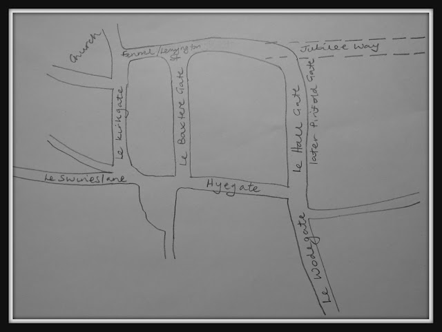
According to Wallace Humphrey (1) in the Elizabethan period (1533-1603 – and possibly just after Leland had passed through the town), streets in the centre of Loughborough included Baxtere Gate, Le Hall Gate, Hyegate, Le Kirkgate, and Le Wodegate: today’s equivalents of these are Baxter Gate, Pinfold Gate, High Street, Church Gate, and Wood Gate. Humphrey refers to Swan Gate as Le Swyneslane, which today is Swan Street.
Looking at a map of the town centre, or trying to envisage the layout of the streets, it becomes clear that they form a grid of fairly straight roads, with High Street on one side, running parallel to Fennel Street, Lemyngton Street and Jubilee Way (now the A6 trunk road), and Church gate, Baxter Gate and Pinfold Gate linking them. Wood Gate crosses High Street and joins Pinfold Gate.
 |
| Grid-like town centre streets |
But why so many ‘Gates’?
To find the answer to this question, we must go back to the time following the occupation of Britain by the Romans. The Romans arrived in the East Midlands in about 43 CE (formerly AD), but by the fifth century, the country was under the control of the Angles. It was the Angles who gave the name Mercia, meaning borderlands, to the East Midlands area. However, by 877 the Angles had moved out, and the Danes had moved in, and towns in the East Midlands were thus ruled by the Danes, under what was known as Danelaw. The area known as Mercia was then split, with the name Mercia being applied to the area now adjacent to Wales, while the region which included Leicester was called the Five Boroughs. The towns in the Five Boroughs later became the county towns of the shires we know today – Leicestershire, Nottinghamshire, Derbyshire and Lincolnshire, but with the exception of Stamford.
The Danish chieftain controlled land in each town that surrounded a fortified burh, or settlement. This is now thought to be the origin of the name of Loughborough – Lehedes burh, so the fortified settlement ruled by a chieftain called Lehedes. It is also from this period that the grid-like layout of the streets emanates, and these are the ‘Gates’ mentioned above.
The Danish word ‘gatte’ means ‘way’ or ‘street’ and this is the origin of our ‘Gates’. There are examples of this usage also in Leicester – Churchgate, Gallowtree Gate and Sanvey Gate – in Lincoln – Michaelgate, Hungate and Broadgate – and in Leeds – Kirkgate, Eastgate and Briggate. Thus, Churchgate or Kirkgate is the road to the church, Gallowtree Gate is the road to the gallows, Briggate is the road to the bridge.
 |
| Church Gate sign in 2013 |
More specifically, Loughborough’s ‘Gates’ simply mean:
Church Gate – the road to the church, in this case, the parish church on Steeple RowBaxter Gate – the road to the baker’s (where Baxter is the Scottish word for baker)
High Gate - is actually the main highway, i.e. the road between the main local towns
Swans Gate – the road that leads to the swans, kept in the nearby swannery
Pinfold Gate – the road that leads to the pinfold, into which stray animals were rounded up
What seems to
be less consistent than the application of the word ‘Gate’ to Loughborough’s
street names is whether this is tacked onto the end of the street name – so Woodgate
– or whether ‘Gate’ becomes the second part of a compound street name – so Pinfold
Gate.
 |
| Swithland slate sign at a pinfold in Woodhouse, 2020 |
 |
| The pinfold at Woodhouse, 2020 |
(1) Richmond, Anne (1992). Elizabethan Loughborough. Loughborough: Loughborough and District Archaeological Society.
You are welcome to quote passages from any of my posts, with appropriate credit. The correct citation for this looks as follows:
Dyer, Lynne (2020). The gates of Loughborough. Available from: https://lynneaboutthestreetsofloughborough.blogspot.com/2020/12/the-gates-of-loughborough.html [Accessed 21 December 2020]
Lynne
Comments
Post a Comment