On a floral theme
The pandemic and subsequent lockdown in the UK in 2020 have meant that walking and discovery activities have been severely curtailed. Thus, in a change to the use of the 2016 map of Loughborough to analyse the streets of the town, as outlined in the scope of this project, today, the voyage of discovery investigates a very new housing estate on the very edge of Loughborough. The rationale behind this investigation is because this area has become very familiar during the local lockdown, which saw residents not being allowed to venture beyond their locality.
As noted in 'Secret Loughborough' (1):
"Loughborough has many examples of thematic naming: after birds; ... after poets; ... after trees etc."
and it is into this group of street names - thematic names - that these new streets fall.
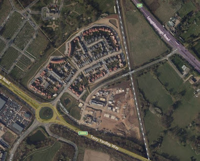
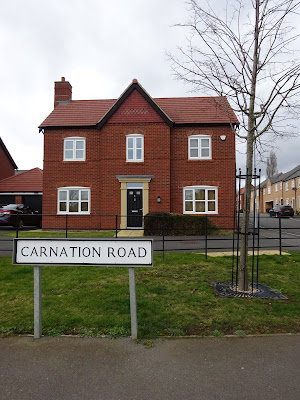
Essentially, the grouping of the new streets with their modern housing form an almost complete figure of eight, and are named according to a lovely theme, appropriate for this time of year. With street names like Daffodil Close, Tulip Crescent, and Violet Lane these names are clearly those of flowers.
Such thematic namings are common across Loughborough, but is there any particular reason why flower names have been chosen for the streets in this area?
Was the theme plucked out of the air, perhaps?
Did the council, or the construction company, or the public come up with the theme?
Perhaps these names are simply random, or maybe there is some specific reason related to the area that lies behind this choice?
In his 'Account of some of the more rare English plants observed in Leicestershire', Richard Pulteney (1730-1801), a Loughborough-born physician and botanist, who also wrote the first English language biography of Carl Linnaeus, details the many rare plants that he had discovered in Leicestershire. Mention is made of a variety of species in and around Loughborough, particularly around the Outwoods and the Holywell Woods, but also in other areas.
Closer to the area we are concerned with, a transcription of Pulteney's words in Nichols 'The history and antiquities of the county of Leicester', states the following:
 |
This entry falls under Linnaeus's classification heading of Decandria, which simply means plants having ten stamens in each flower. However, this terminology is now obsolete, and indeed was never intended to represent any natural grouping of plants.
The subterranean trefoil is a species of clover which is now grown for animal feed, but at the time Pulteney was writing, it was classed as a roadside weed. It differs from other clovers in three ways: its seeds develop underground; the plant can thrive in poor quality soil and it is self-fertilising. The Ornithopus mentioned above is presumably the birds foot trefoil, and together these plants were found near the Quorn turnpike road. Whether that was the Leicester end or the Loughborough end of the turnpike road, now the A6, is unclear.
 |
| Although this dried bird's foot refoil has discoloured since 1968 when it was legal to collect wild flowers, the bird's foot trefoil has yellow flowers |
 |
| A representation of a bird's foot trefoil |
From Pulteney's own words, which appeared in 'Philosophical transactions', Vol.XLIX, Part II, 1756:
we can be sure that the Trifolium Glomeratum – the round-headed trefoil
– was found in the fields where this new housing development has grown up, for
the mention of the Needless Inn, and the ‘closes opposite’ pinpoint the location
almost exactly. The Needless Inn is now the Bull-in-the-Hollow farm, and
opposite this lies a field which is currently being developed for new housing,
the track of the Great Central Railway, which was created in 1898, and beyond
that is the housing development which is the subject of this post. Before its development,
this was a field full of wildflowers, with a public footpath across it, leading
from Lodge Lane to the Loughborough cemetery. The footpath has been retained,
but the field is now full of houses.
 |
| Trefoils |
 |
| This is the area in 1901 with the Needless Inn listed as Woodthorpe Nursery |
The above map shows the area in 1901, with the Needless Inn top right, listed as Woodthorpe Nursery, the Great Central Railway line to the left of the Inn, the cemetery being just out of shot, top left, and the fields numbered 65, 66 and 96 being signifcant. The footpath runs along the same line as the GCR, to its left.
 |
| A more up-to-date map |
The more up-to-date map shows the same area, which although feels a figure-of-eight shape when walking the footpath, and around the perimeter, is more a crystal shape.
 |
| The footpath during the housing construction |
 |
| More housing being built in field 67 |
 |
| The Bull-in-the-Hollow farm, formerly the Woodthorpe Nursery and the Needless Inn |
 |
| Cornflower Road |
The question still remains, however, as to whether or not the streets of the new housing development were named because they are in a former wildflower field, or whether this is simply a pleasant name, for a pleasant place to live, akin to Acacia Avenue.
Posted by lynneaboutloughborough 16 March 2021
References: Dyer, Lynne (2018). Secret Loughborough. Stroud: Amberley
You are welcome to quote passages from any of my posts, with appropriate credit. The correct citation for this looks as follows:
Dyer, Lynne (2021). On a floral theme. Available from: https://lynneaboutthestreetsofloughborough.blogspot.com/2021/03/on-floral-theme.html [Accessed March 2021]


Comments
Post a Comment